
Watermael topographic map
Interactive map
Click on the map to display elevation.
About this map
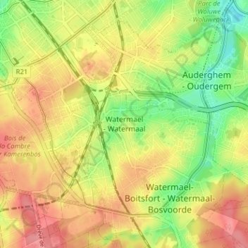
Name: Watermael topographic map, elevation, terrain.
Average elevation: 86 m
Minimum elevation: 42 m
Maximum elevation: 123 m
Other topographic maps
Click on a map to view its topography, its elevation and its terrain.
Parc Tournay-Solvay
Belgique > Bruxelles-Capitale > Watermael-Boitsfort > Boitsfort
Parc Tournay-Solvay, Boitsfort, Watermael-Boitsfort, Bruxelles-Capitale, 1170, Belgique
Average elevation: 97 m
Watermael-Boitsfort
Belgique > Bruxelles-Capitale > Watermael-Boitsfort
Watermael-Boitsfort, Bruxelles-Capitale, 1170, Belgique
Average elevation: 97 m