
Siguldas novads topographic map
Interactive map
Click on the map to display elevation.
About this map
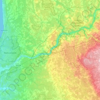
Name: Siguldas novads topographic map, elevation, terrain.
Location: Siguldas novads, Lijfland, Letland (56.92293 24.49841 57.41006 25.15707)
Average elevation: 69 m
Minimum elevation: 0 m
Maximum elevation: 228 m
Other topographic maps
Click on a map to view its topography, its elevation and its terrain.
Salas pagasts
Letland > Lijfland > Mārupes novads
Salas pagasts, Mārupes novads, Lijfland, LV-2105, Letland
Average elevation: 5 m
Vecsalaca
Letland > Lijfland > Limbažu novads
Vecsalaca, Limbažu novads, Lijfland, LV-4033, Letland
Average elevation: 13 m
Carnikavas pagasts
Letland > Lijfland > Ādažu novads
Carnikavas pagasts, Ādažu novads, Lijfland, LV-2163, Letland
Average elevation: 5 m
Kūdums
Letland > Lijfland > Cēsu novads > Raiskuma pagasts
Kūdums, Raiskuma pagasts, Cēsu novads, Lijfland, LV-4146, Letland
Average elevation: 66 m
Sunīši
Letland > Lijfland > Siguldas novads > Krimuldas pagasts
Sunīši, Krimuldas pagasts, Siguldas novads, Lijfland, Letland
Average elevation: 49 m
Strautiņu mācību un pāraudzināšanas iestāde
Letland > Lijfland > Alūksnes novads
Strautiņu mācību un pāraudzināšanas iestāde, Alūksnes novads, Lijfland, Letland
Average elevation: 137 m