Geolocate

Fowey topographic map

Click on the map to display elevation.

About this map

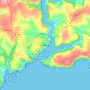
Name: Fowey topographic map, elevation, terrain.

Location: Fowey, Cornwall, England, United Kingdom (50.31331 -4.69157 50.35810 -4.63026)

Average elevation: 44 m

Minimum elevation: 0 m

Maximum elevation: 129 m

Other topographic maps

Click on a map to view its topography, its elevation and its terrain.

Boscastle

United Kingdom > England > Cornwall

Average elevation: 93 m

Tolcarne

United Kingdom > England > Cornwall

Average elevation: 213 m

Bolventor

United Kingdom > England > Cornwall

Average elevation: 276 m

St Blazey

United Kingdom > England > Cornwall

Average elevation: 75 m

Fraddon

United Kingdom > England > Cornwall

Average elevation: 121 m