
Thank you for supporting this site ❤️
Make a donation
Make a donation
Merstham topographic map
Click on the map to display elevation.
Thank you for supporting this site ❤️
Make a donation
Make a donation
About this map
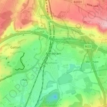
Name: Merstham topographic map, elevation, terrain.
Average elevation: 119 m
Minimum elevation: 46 m
Maximum elevation: 219 m
Thank you for supporting this site ❤️
Make a donation
Make a donation
Other topographic maps
Click on a map to view its topography, its elevation and its terrain.
Horley
United Kingdom > England > Surrey > Reigate and Banstead
Horley is at an altitude of around 54 metres above mean sea level.
Average elevation: 58 m