
Thank you for supporting this site ❤️
Make a donation
Make a donation
King George County topographic map
Click on the map to display elevation.
Thank you for supporting this site ❤️
Make a donation
Make a donation
About this map
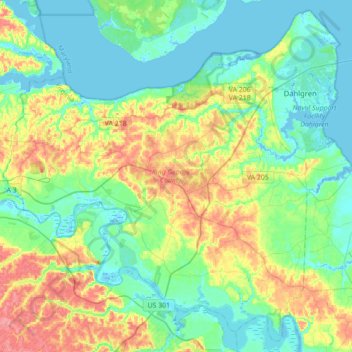
Name: King George County topographic map, elevation, terrain.
Location: King George County, Virginia, United States (38.14198 -77.34757 38.40090 -76.99737)
Average elevation: 23 m
Minimum elevation: -6 m
Maximum elevation: 75 m
Thank you for supporting this site ❤️
Make a donation
Make a donation
Other topographic maps
Click on a map to view its topography, its elevation and its terrain.
Deep Creek
United States > Virginia > Accomack County
It lies at an elevation of 3 feet.
Average elevation: 1 m
Thank you for supporting this site ❤️
Make a donation
Make a donation
Thank you for supporting this site ❤️
Make a donation
Make a donation
Forest Hill Park
United States > Virginia > Williamsburg (city) > Williamsburg > Forest Hill Park
Average elevation: 22 m
Thank you for supporting this site ❤️
Make a donation
Make a donation