
Shuncheng District topographic map
Interactive map
Click on the map to display elevation.
About this map
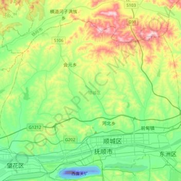
Name: Shuncheng District topographic map, elevation, terrain.
Location: Shuncheng District, Fushun City, Liaoning, 113000, China (41.85522 123.75346 42.03108 124.05200)
Average elevation: 166 m
Minimum elevation: -259 m
Maximum elevation: 549 m
Other topographic maps
Click on a map to view its topography, its elevation and its terrain.
Taiping District
Taiping District, Fuxin City, Liaoning, 123000, China
Average elevation: 235 m
Donggang
China > Liaoning > Donggang City > Dadong Subdistrict
Donggang, Dadong Subdistrict, Donggang City, Dandong City, Liaoning, China
Average elevation: 7 m
Gongji Subdistrict
China > Liaoning > Wafangdian City
Gongji Subdistrict, Wafangdian City, Dalian City, Liaoning, China
Average elevation: 113 m
Fenghuangcheng Subdistrict
China > Liaoning > Fengcheng City
Fenghuangcheng Subdistrict, Fengcheng City, Dandong City, Liaoning, 118100, China
Average elevation: 122 m
Wenquan Subdistrict
China > Liaoning > Xingcheng City > Huludao City
Wenquan Subdistrict, Xingcheng City, Huludao City, Liaoning, China
Average elevation: 24 m
Gulou
China > Liaoning > Gaizhou City > Yingkou City
Gulou, Gaizhou City, Yingkou City, Liaoning, China
Average elevation: 11 m
Wushujie Subdistrict
China > Liaoning > Diaobingshan City
Wushujie Subdistrict, Diaobingshan City, Tieling City, Liaoning, China
Average elevation: 120 m
Shenhe District
Shenhe District, Shenyang City, Liaoning, China
Average elevation: 51 m
Gongren Subdistrict
China > Liaoning > Yinzhou District
Gongren Subdistrict, Yinzhou District, Tieling City, Liaoning, China
Average elevation: 69 m
Pingshan District
Pingshan District, Benxi City, Liaoning, China
Average elevation: 244 m
Baguacheng Subdistrict
China > Liaoning > Huanren Manchu Autonomous County
Baguacheng Subdistrict, Huanren Manchu Autonomous County, Benxi City, Liaoning, China
Average elevation: 307 m
Haizhou Subdistrict
China > Liaoning > Haicheng City
Haizhou Subdistrict, Haicheng City, Anshan City, Liaoning, China
Average elevation: 83 m
Chengguan Subdistrict
China > Liaoning > Zhuanghe City
Chengguan Subdistrict, Zhuanghe City, Dalian City, Liaoning, 116400, China
Average elevation: 12 m
Kaiyuan
China > Liaoning > Kaiyuan City > Xincheng Subdistrict
Kaiyuan, Xincheng Subdistrict, Kaiyuan City, Tieling City, Liaoning, China
Average elevation: 123 m
Nanjie Subdistrict
China > Liaoning > Lingyuan City > Chaoyang City
Nanjie Subdistrict, Lingyuan City, Chaoyang City, Liaoning, China
Average elevation: 418 m
Changhai County
Changhai County, Dalian City, Liaoning, 116500, China
Average elevation: 2 m
Xifeng County
China > Liaoning > Xifeng County
Xifeng County, Tieling City, Liaoning, China
Average elevation: 300 m
Fuxin
China > Liaoning > Fuxin > Zhongyuan Subdistrict
Fuxin, Zhongyuan Subdistrict, Xihe District, Fuxin City, Liaoning, 123000, China
Average elevation: 223 m
Benxi
China > Liaoning > Benxi > Dongming Subdistrict
Benxi, Dongming Subdistrict, Pingshan District, Benxi City, Liaoning, 117000, China
Average elevation: 281 m
Taian
China > Liaoning > Tai'an County > Taian
Taian, Tai'an County, Anshan City, Liaoning, China
Average elevation: 10 m
Anshan
China > Liaoning > Shengli Subdistrict
Anshan, Shengli Subdistrict, Tiedong District, Anshan City, Liaoning, China
Average elevation: 79 m
Hongqiyingzi
China > Liaoning > Xiuyan Manchu Autonomous County > Hongqiyingzi
Hongqiyingzi, Xiuyan Manchu Autonomous County, Anshan City, Liaoning, China
Average elevation: 169 m
Baita District
China > Liaoning > Baita District
Baita District, Liaoyang City, Liaoning, 111000, China
Average elevation: 28 m
Anshan
China > Liaoning > Anshan > Shengli Subdistrict
Anshan, Shengli Subdistrict, Tiedong District, Anshan City, Liaoning, China
Average elevation: 79 m
Taoxian
China > Liaoning > Shenyang City > Taoxian
Taoxian, Hunnan District, Shenyang City, Liaoning, 110169, China
Average elevation: 61 m
Xishi District
China > Liaoning > Yingkou City
Xishi District, Yingkou City, Liaoning, 115000, China
Average elevation: 2 m
Zhanqian Subdistrict
Zhanqian Subdistrict, Dandong, Zhenxing District, Dandong City, Liaoning, 118000, China
Average elevation: 59 m