
Levan topographic map
Interactive map
Click on the map to display elevation.
About this map
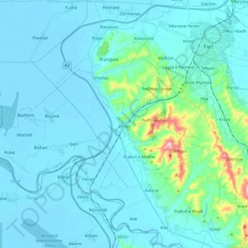
Name: Levan topographic map, elevation, terrain.
Location: Levan, Fier, Fier County, Southern Albania, 9314, Albania (40.63328 19.37109 40.72055 19.57315)
Average elevation: 31 m
Minimum elevation: -3 m
Maximum elevation: 295 m
Other topographic maps
Click on a map to view its topography, its elevation and its terrain.
Fier
Albania > Southern Albania > Fier County > Fier
Fier, Fier County, Southern Albania, Albania
Average elevation: 18 m
Ada
Albania > Southern Albania > Fier County > Fier
Ada, Fier, Fier County, Southern Albania, 9313, Albania
Average elevation: 18 m