
Chaumont topographic map
Interactive map
Click on the map to display elevation.
About this map
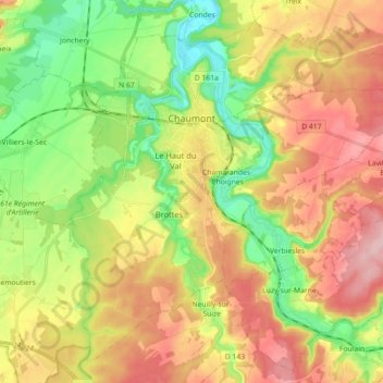
Name: Chaumont topographic map, elevation, terrain.
Average elevation: 325 m
Minimum elevation: 246 m
Maximum elevation: 413 m
Other topographic maps
Click on a map to view its topography, its elevation and its terrain.
Joinville
France > Grand Est > Haute-Marne
Joinville, Saint-Dizier, Haute-Marne, Grand Est, Metropolitan France, 52300, France
Average elevation: 267 m