
Կիրանց topographic map
Interactive map
Click on the map to display elevation.
About this map
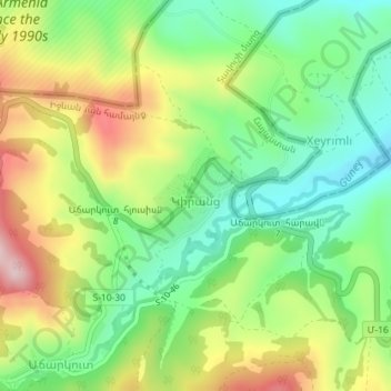
Name: Կիրանց topographic map, elevation, terrain.
Location: Կիրանց, Իջևան համայնք, Provinz Tawusch, Armenien (41.04386 45.09221 41.05073 45.10316)
Average elevation: 771 m
Minimum elevation: 651 m
Maximum elevation: 948 m
Other topographic maps
Click on a map to view its topography, its elevation and its terrain.
Idschewan
Armenien > Provinz Tawusch > Idschewan
Idschewan, Provinz Tawusch, 4001, Armenien
Average elevation: 813 m