
Make a donation
West topographic map
Click on the map to display elevation.
Make a donation
About this map
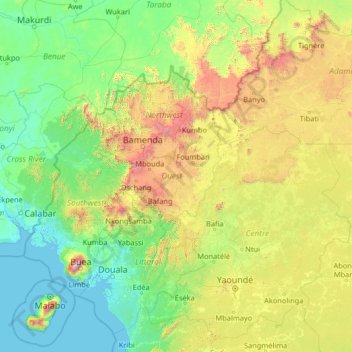
Name: West topographic map, elevation, terrain.
Location: West, Cameroon (2.92112 8.05287 8.12112 13.25287)
Average elevation: 529 m
Minimum elevation: -1 m
Maximum elevation: 3,977 m
Make a donation
Other topographic maps
Click on a map to view its topography, its elevation and its terrain.
Far-North
These rivers all follow a tropical regime, fluctuating between high water in the wet season (May to September) and low water in the dry season (October to April). At the height of the dry season, many of the waterways disappear completely or else diminish to a mere trickle. The Logone all but disappears during…
Average elevation: 357 m
South
The South Region begins at sea level on the coast. The land slowly climbs throughout the Kribi-Douala basin, which averages 300–600 metres in altitude, until it reaches the South Cameroon Plateau with elevations of 500 to 1000 metres above sea level. Rocky promontories on the coast and rolling, tree-covered…
Average elevation: 498 m
Make a donation
East
Almost the entire territory of the East Region lies on the South Cameroon Plateau that forms the southeastern half of the country. The elevation thus varies between 500 and 1000 metres above sea level except for lower-lying plains of 200 to 500 metres in the extreme southeast centered on the Dja, Boumba,…
Average elevation: 643 m
Make a donation
Yaounde
Yaoundé (UK: /jɑːˈʊndeɪ, -ˈuːn-/; US: /ˌjɑːʊnˈdeɪ/, French pronunciation: [ja.unde]) is the capital of Cameroon and, with a population of more than 2.8 million, the second-largest city in the country after the port city Douala. It lies in the Centre Region of the nation at an elevation of…
Average elevation: 724 m