Geolocate

Betong topographic map

Interactive map

Click on the map to display elevation.

About this map

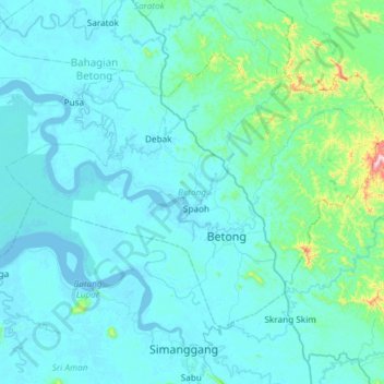
Name: Betong topographic map, elevation, terrain.

Location: Betong, Betong Division, Sarawak, Malaysia (1.26905 111.18750 1.69010 111.77925)

Average elevation: 55 m

Minimum elevation: -4 m

Maximum elevation: 806 m

Other topographic maps

Click on a map to view its topography, its elevation and its terrain.

Sarikei

Malaysia > Sarawak > Sarikei

Average elevation: 14 m

Kota Samarahan

Malaysia > Sarawak > Samarahan

Average elevation: 9 m

Kampung Senah Rayang

Malaysia > Sarawak > Tebedu

Average elevation: 205 m

Engkilili

Malaysia > Sarawak > Lubok Antu

Average elevation: 24 m

Sungai Kuap

Malaysia > Sarawak > Kuching

Average elevation: 4 m

Batang Ai

Malaysia > Sarawak

Average elevation: 122 m

Miri Division

Malaysia > Sarawak

Average elevation: 95 m