
Guntung Paikat topographic map
Interactive map
Click on the map to display elevation.
About this map
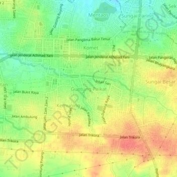
Name: Guntung Paikat topographic map, elevation, terrain.
Average elevation: 34 m
Minimum elevation: 6 m
Maximum elevation: 60 m
Other topographic maps
Click on a map to view its topography, its elevation and its terrain.
Loktabat Selatan
Indonésie > Kalimantan du Sud > Banjarbaru > Loktabat Selatan
Loktabat Selatan, Banjarbaru, Kalimantan du Sud, 70712, Indonésie
Average elevation: 27 m