
Weizberg topographic map
Interactive map
Click on the map to display elevation.
About this map
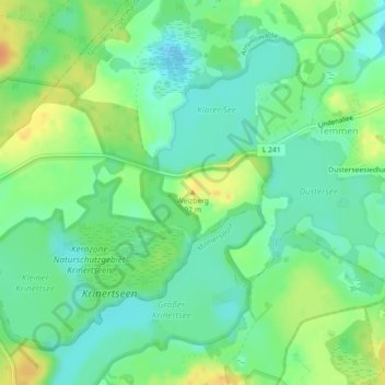
Name: Weizberg topographic map, elevation, terrain.
Average elevation: 73 m
Minimum elevation: 59 m
Maximum elevation: 94 m
Other topographic maps
Click on a map to view its topography, its elevation and its terrain.
Meichow
Deutschland > Brandenburg > Uckermark > Gramzow > Gramzow
Meichow, Gramzow, Uckermark, Brandenburg, Deutschland
Average elevation: 64 m
Gartz (Oder)
Deutschland > Brandenburg > Uckermark
Gartz (Oder), Uckermark, Brandenburg, 16307, Deutschland
Average elevation: 22 m
Boitzenburger Land
Deutschland > Brandenburg > Uckermark
Boitzenburger Land, Uckermark, Brandenburg, Deutschland
Average elevation: 89 m