
Thank you for supporting this site ❤️
Make a donation
Make a donation
Ontario topographic map
Click on the map to display elevation.
Thank you for supporting this site ❤️
Make a donation
Make a donation
About this map
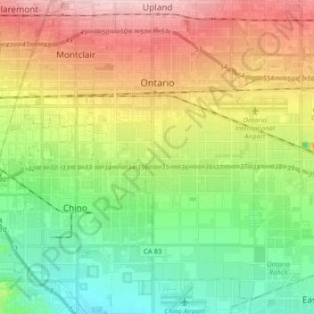
Name: Ontario topographic map, elevation, terrain.
Location: Ontario, San Bernardino County, California, United States (33.97531 -117.68294 34.09336 -117.52407)
Average elevation: 261 m
Minimum elevation: 173 m
Maximum elevation: 392 m
Thank you for supporting this site ❤️
Make a donation
Make a donation
Other topographic maps
Click on a map to view its topography, its elevation and its terrain.
Serrano Village
United States > California > San Bernardino County > San Bernardino
Average elevation: 489 m