
Thank you for supporting this site ❤️
Make a donation
Make a donation
Almaș topographic map
Click on the map to display elevation.
Thank you for supporting this site ❤️
Make a donation
Make a donation
About this map
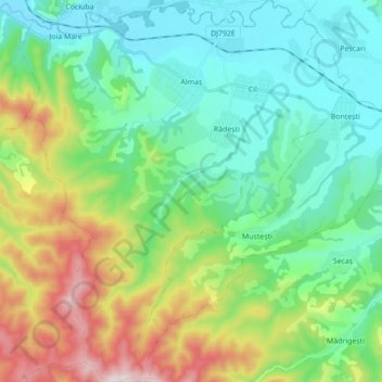
Name: Almaș topographic map, elevation, terrain.
Location: Almaș, Arad, Romania (46.19057 22.15796 46.31103 22.30430)
Average elevation: 334 m
Minimum elevation: 139 m
Maximum elevation: 832 m
Thank you for supporting this site ❤️
Make a donation
Make a donation
Other topographic maps
Click on a map to view its topography, its elevation and its terrain.
Thank you for supporting this site ❤️
Make a donation
Make a donation
Thank you for supporting this site ❤️
Make a donation
Make a donation