
Chalet - Hôtel Orédon topographic map
Interactive map
Click on the map to display elevation.
About this map
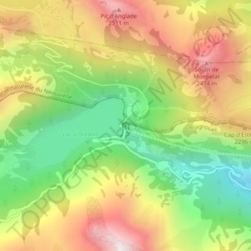
Name: Chalet - Hôtel Orédon topographic map, elevation, terrain.
Average elevation: 2,094 m
Minimum elevation: 1,645 m
Maximum elevation: 2,583 m
Other topographic maps
Click on a map to view its topography, its elevation and its terrain.
Réserve naturelle du Néouvielle
France > Occitanie > Hautes-Pyrénées > Aragnouet > Soulan
Réserve naturelle du Néouvielle, D 177, Soulan, Aragnouet, Bagnères-de-Bigorre, Hautes-Pyrénées, Occitanie, France métropolitaine, 65170, France
Average elevation: 2,267 m