
Fürsteneck topographic map
Interactive map
Click on the map to display elevation.
About this map
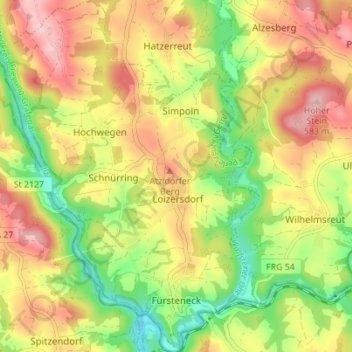
Name: Fürsteneck topographic map, elevation, terrain.
Average elevation: 431 m
Minimum elevation: 333 m
Maximum elevation: 528 m
Other topographic maps
Click on a map to view its topography, its elevation and its terrain.
Hohenau
Deutschland > Bayern > Landkreis Freyung-Grafenau
Hohenau, Landkreis Freyung-Grafenau, Bayern, 94545, Deutschland
Average elevation: 729 m
Jandelsbrunn
Deutschland > Bayern > Landkreis Freyung-Grafenau
Jandelsbrunn, Landkreis Freyung-Grafenau, Bayern, 94118, Deutschland
Average elevation: 689 m
Waldkirchen
Deutschland > Bayern > Landkreis Freyung-Grafenau
Waldkirchen, Landkreis Freyung-Grafenau, Bayern, 94065, Deutschland
Average elevation: 599 m