
Satimpo topographic map
Interactive map
Click on the map to display elevation.
About this map
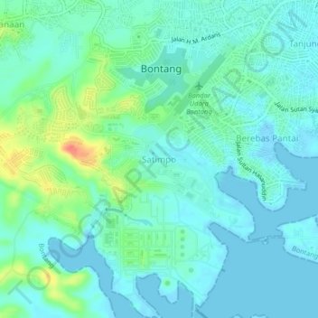
Name: Satimpo topographic map, elevation, terrain.
Average elevation: 12 m
Minimum elevation: -1 m
Maximum elevation: 52 m
Other topographic maps
Click on a map to view its topography, its elevation and its terrain.
Api-api
Indonesia > East Kalimantan > Bontang
Api-api, Bontang, East Kalimantan, Kalimantan, 75311, Indonesia
Average elevation: 6 m
Tanjung Laut
Indonesia > East Kalimantan > Bontang
Tanjung Laut, Bontang, East Kalimantan, 75311, Indonesia
Average elevation: 6 m
Berbas Tengah
Indonesia > East Kalimantan > Bontang
Berbas Tengah, Bontang, East Kalimantan, 77435, Indonesia
Average elevation: 10 m