
Thank you for supporting this site ❤️
Make a donation
Make a donation
Forcatura topographic map
Click on the map to display elevation.
Thank you for supporting this site ❤️
Make a donation
Make a donation
About this map
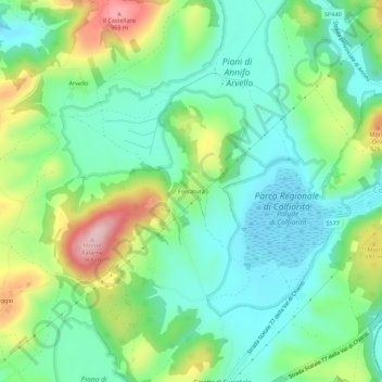
Name: Forcatura topographic map, elevation, terrain.
Location: Forcatura, Foligno, Perugia, Umbria, 06034, Italia (43.00678 12.84176 43.04678 12.88176)
Average elevation: 819 m
Minimum elevation: 745 m
Maximum elevation: 980 m
Thank you for supporting this site ❤️
Make a donation
Make a donation
Other topographic maps
Click on a map to view its topography, its elevation and its terrain.