
Whanganui District topographic map
Interactive map
Click on the map to display elevation.
About this map
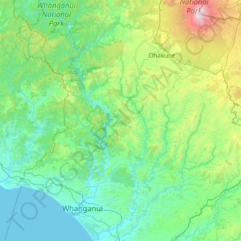
Name: Whanganui District topographic map, elevation, terrain.
Location: Whanganui District, Manawatū-Whanganui, Nova Zelândia (-40.04108 174.76629 -39.23050 175.51536)
Average elevation: 391 m
Minimum elevation: -1 m
Maximum elevation: 2,727 m
Other topographic maps
Click on a map to view its topography, its elevation and its terrain.
Tongariro National Park
Nova Zelândia > Manawatū-Whanganui > Ruapehu District
Tongariro National Park, Ruapehu District, Manawatū-Whanganui, Nova Zelândia
Average elevation: 888 m
Ruapehu District
Nova Zelândia > Manawatū-Whanganui
Ruapehu District, Manawatū-Whanganui, Nova Zelândia
Average elevation: 531 m