
Thank you for supporting this site ❤️
Make a donation
Make a donation
Gedung Aji topographic map
Click on the map to display elevation.
Thank you for supporting this site ❤️
Make a donation
Make a donation
About this map
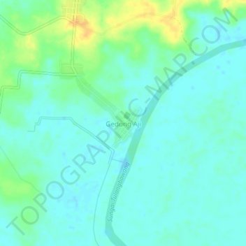
Name: Gedung Aji topographic map, elevation, terrain.
Location: Gedung Aji, Tulang Bawang, Lampung, Sumatra, Indonesia (-4.34314 105.34691 -4.30314 105.38691)
Average elevation: 8 m
Minimum elevation: 0 m
Maximum elevation: 27 m
Thank you for supporting this site ❤️
Make a donation
Make a donation