
Thank you for supporting this site ❤️
Make a donation
Make a donation
Bellentre topographic map
Click on the map to display elevation.
Thank you for supporting this site ❤️
Make a donation
Make a donation
Bellentre
Sous l'impulsion de son maire Auguste Mudry, la station village de Montchavin, à 1 250 m d'altitude, voit le jour en 1972.
Thank you for supporting this site ❤️
Make a donation
Make a donation
About this map
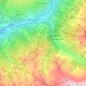
Name: Bellentre topographic map, elevation, terrain.
Average elevation: 1,704 m
Minimum elevation: 661 m
Maximum elevation: 3,404 m
Thank you for supporting this site ❤️
Make a donation
Make a donation