
Thank you for supporting this site ❤️
Make a donation
Make a donation
Prospect Hill topographic map
Click on the map to display elevation.
Thank you for supporting this site ❤️
Make a donation
Make a donation
About this map
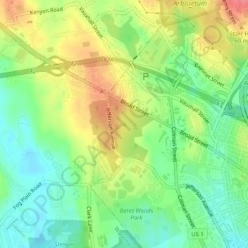
Name: Prospect Hill topographic map, elevation, terrain.
Average elevation: 38 m
Minimum elevation: 7 m
Maximum elevation: 78 m
Thank you for supporting this site ❤️
Make a donation
Make a donation
Other topographic maps
Click on a map to view its topography, its elevation and its terrain.
Fort Trumbull State Park
United States > Connecticut > Southeastern Connecticut Planning Region > New London
Average elevation: 12 m