
Make a donation
Lituya Bay topographic map
Click on the map to display elevation.
Make a donation
Lituya Bay
The same topography that leads to the heavy tidal currents also created the tsunami with the highest runup against a hillside in recorded history. On July 9, 1958, an earthquake caused a landslide in the Gilbert Inlet at the head of the bay, generating a massive megatsunami which had sufficient energy to run up the hill slope just opposite of the landslide to a height measuring 1,722 feet (525 m), taller than the Empire State Building. There were three fishing boats anchored near the entrance of Lituya Bay on the day the giant wave occurred. One boat (the Sunmore) was sunk by the wave and debris as it attempted to exit the bay, and the two people on board (a married couple, the Wagners) were killed. The second boat (the Badger) was carried across the la Chasseuse, spit into the ocean, hit by a floating log and sunk but not before its occupants (a married couple, the Swansons) in spite of injuries, managed to board a skiff ultimately to be rescued. The third boat, the Edrie, crewed by father and son the Ulriches, was anchored at the opposite side of the bay entrance. The father, Howard, turned the boat to face the wave, which picked her up, snapped her anchor chain, carried her above the trees but then washed her back into the bay with no major damage. William A. Swanson and Howard G. Ulrich provided accounts of what they observed. Based on Swanson's description of the length of time it took the wave to reach his boat after overtopping Cenotaph Island near the bay's entrance, the wave may have been traveling 120 mph (190 km/h). When it reached the open sea, however, it dissipated quickly. This incident was the first direct evidence and eyewitness report of the existence of megatsunamis.
Make a donation
About this map
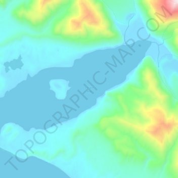
Name: Lituya Bay topographic map, elevation, terrain.
Location: Lituya Bay, Unorganized Borough, Alaska, United States (58.61141 -137.67592 58.66618 -137.48479)
Average elevation: 217 m
Minimum elevation: -11 m
Maximum elevation: 1,593 m
Make a donation
Other topographic maps
Click on a map to view its topography, its elevation and its terrain.
Mount Crillon
United States > Alaska > Unorganized Borough
Mount Crillon is not climbed frequently, since it is an extremely challenging climb for its elevation due to its isolation. The first ascent was in 1934, by explorer Bradford Washburn on his third attempt, and longtime editor of the American Alpine Journal H. Adams Carter. They climbed via the East Ridge above…
Average elevation: 2,891 m
Make a donation
Make a donation
Make a donation
Make a donation
Make a donation
Make a donation
Make a donation
Make a donation
Make a donation
Make a donation
Make a donation
Make a donation
Make a donation
Make a donation
Glacier Bay National Park and Preserve
United States > Alaska > Unorganized Borough > Gustavus
Average elevation: 22 m
Mount Hayes
United States > Alaska > Unorganized Borough
Mount Hayes is the highest mountain in the eastern Alaska Range, in the U.S. state of Alaska. Despite not being a fourteener, it is one of the largest peaks in the United States in terms of rise above local terrain. For example, the Northeast Face rises 8,000 feet (2,440 m) in approximately 2 miles (3.2 km).…
Average elevation: 3,235 m
Make a donation
Make a donation
Make a donation
Make a donation
Make a donation
Make a donation
Fort Yukon
United States > Alaska > Unorganized Borough > Fort Yukon
On February 7, 1984, a Terrier Malemute-type sounding rocket, with a maximum altitude of 310 miles (500 km), was launched from Fort Yukon.
Average elevation: 133 m
Make a donation
Make a donation
Make a donation
Make a donation
Make a donation