
Pesenthein am Millstätter See topographic map
Interactive map
Click on the map to display elevation.
About this map
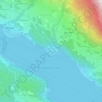
Name: Pesenthein am Millstätter See topographic map, elevation, terrain.
Average elevation: 769 m
Minimum elevation: 583 m
Maximum elevation: 1,609 m
Other topographic maps
Click on a map to view its topography, its elevation and its terrain.
Sappl
Oostenrijk > Karinthië > Bezirk Spittal an der Drau > Millstatt am See > Sappl
Sappl, Millstatt am See, Bezirk Spittal an der Drau, Karinthië, 9872, Oostenrijk
Average elevation: 921 m