
Thank you for supporting this site ❤️
Make a donation
Make a donation
Kelaniya topographic map
Click on the map to display elevation.
Thank you for supporting this site ❤️
Make a donation
Make a donation
About this map
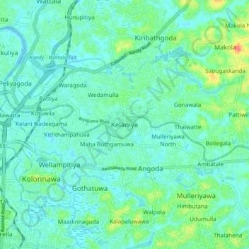
Name: Kelaniya topographic map, elevation, terrain.
Location: Kelaniya, Colombo District, Western Province, 11600, Sri Lanka (6.91012 79.87727 6.99012 79.95727)
Average elevation: 11 m
Minimum elevation: -2 m
Maximum elevation: 48 m
Thank you for supporting this site ❤️
Make a donation
Make a donation
Other topographic maps
Click on a map to view its topography, its elevation and its terrain.
Thank you for supporting this site ❤️
Make a donation
Make a donation
Thank you for supporting this site ❤️
Make a donation
Make a donation
Thank you for supporting this site ❤️
Make a donation
Make a donation
Thank you for supporting this site ❤️
Make a donation
Make a donation
Uyanwatta Lake
Sri Lanka > Western Province > Bandaragama DS Division > Gelanigama
Average elevation: 16 m
Thank you for supporting this site ❤️
Make a donation
Make a donation
Thank you for supporting this site ❤️
Make a donation
Make a donation
Thank you for supporting this site ❤️
Make a donation
Make a donation
Thank you for supporting this site ❤️
Make a donation
Make a donation
Thank you for supporting this site ❤️
Make a donation
Make a donation
Thank you for supporting this site ❤️
Make a donation
Make a donation
Wevita Lake
Sri Lanka > Western Province > Bandaragama DS Division > Bandaragama
Average elevation: 9 m
Thank you for supporting this site ❤️
Make a donation
Make a donation
Thank you for supporting this site ❤️
Make a donation
Make a donation
Thank you for supporting this site ❤️
Make a donation
Make a donation