
Make a donation
Navarino Island topographic map
Click on the map to display elevation.
Make a donation
Navarino Island
Immediately to the south is the evergreen Magellanic rainforest, probably associated with the increased precipitation, the greater altitude and an improvement in the drainage. The characteristic species is Nothofagus betuloides (Coihue of Magallanes), forming pure communities in sectors of greater altitude or coasts exposed to the wind.
Make a donation
About this map
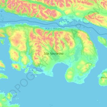
Name: Navarino Island topographic map, elevation, terrain.
Average elevation: 172 m
Minimum elevation: 0 m
Maximum elevation: 1,341 m
Make a donation
Other topographic maps
Click on a map to view its topography, its elevation and its terrain.
Punta Arenas
Chile > Region of Magallanes and Chilean Antarctica > Provincia de Magallanes > Punta Arenas
Average elevation: 122 m
Puerto Williams
Chile > Region of Magallanes and Chilean Antarctica > Provincia de la Antártica Chilena > Cape Horn > Puerto Williams
Average elevation: 151 m