
Make a donation
Fairhope topographic map
Click on the map to display elevation.
Make a donation
Fairhope
According to the U.S. Census Bureau, the city has a total area of 12.0 square miles (31.1 km2), of which 0.019 square mile (0.05 km2), or 0.16%, is water. Its elevation ranges from sea level at the bay to 122 feet (37 m) in the city center.
Make a donation
About this map
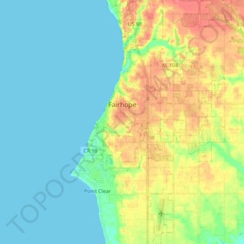
Name: Fairhope topographic map, elevation, terrain.
Location: Fairhope, Baldwin County, Alabama, United States (30.44387 -87.92498 30.58224 -87.83542)
Average elevation: 17 m
Minimum elevation: 0 m
Maximum elevation: 49 m
Make a donation
Other topographic maps
Click on a map to view its topography, its elevation and its terrain.
Make a donation
Make a donation
Ono Island
United States > Alabama > Baldwin County
Ono Island was along the boundary of the treaties between France and Spain. In 1813, after protests and attempts at rebellion, President James Monroe seized Spanish lands west of the Perdido River and declared them a part of the Louisiana Purchase of 1803. This set the east end of the Island, Perdido Key, at…
Average elevation: 9 m
Make a donation
Make a donation