
Mackenzie District topographic map
Interactive map
Click on the map to display elevation.
About this map
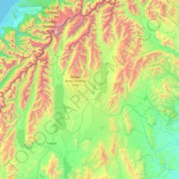
Name: Mackenzie District topographic map, elevation, terrain.
Location: Mackenzie District, Canterbury, Nouvelle-Zélande (-44.46605 169.81552 -43.40989 171.22274)
Average elevation: 961 m
Minimum elevation: 0 m
Maximum elevation: 3,666 m
Other topographic maps
Click on a map to view its topography, its elevation and its terrain.
Christchurch
Nouvelle-Zélande > Canterbury > Christchurch City
Christchurch, Christchurch City, Canterbury, Nouvelle-Zélande
Average elevation: 41 m
Mount Sutton
Nouvelle-Zélande > Canterbury > Waitaki District
Mount Sutton, Waitaki District, Canterbury, Nouvelle-Zélande
Average elevation: 1,656 m
Ōhau River
Ōhau River, Waitaki District, Canterbury, 7901, Nouvelle-Zélande
Average elevation: 566 m
Poulter River East Branch
Poulter River East Branch, Selwyn District, Canterbury, Nouvelle-Zélande
Average elevation: 962 m
Lake Aviemore
Lake Aviemore, Te Akatarawa Road, Waimate District, Canterbury, Nouvelle-Zélande
Average elevation: 513 m
Lake Benmore
Lake Benmore, Falston Road, Waitaki District, Canterbury, Nouvelle-Zélande
Average elevation: 746 m
Lake Ellesmere
Nouvelle-Zélande > Canterbury > Greenpark Huts
Lake Ellesmere, Fuller Street, Greenpark Huts, Selwyn District, Canterbury, Nouvelle-Zélande
Average elevation: 16 m
Christchurch City
Christchurch City, Canterbury, Nouvelle-Zélande
Average elevation: 74 m
Lake Coleridge
Nouvelle-Zélande > Canterbury > Lake Coleridge
Lake Coleridge, Selwyn District, Canterbury, Nouvelle-Zélande
Average elevation: 422 m
Lake Ohau
Nouvelle-Zélande > Canterbury > Ohau
Lake Ohau, Lake Ohau Road, Ohau, Waitaki District, Canterbury, Nouvelle-Zélande
Average elevation: 904 m
Mount Vancouver
Mount Vancouver, Mackenzie District, Canterbury, Nouvelle-Zélande
Average elevation: 2,804 m
Île du Sud
Île du Sud, Ashburton District, Canterbury, Nouvelle-Zélande
Average elevation: 201 m