
Thank you for supporting this site ❤️
Make a donation
Make a donation
Sorsogon River topographic map
Click on the map to display elevation.
Thank you for supporting this site ❤️
Make a donation
Make a donation
About this map
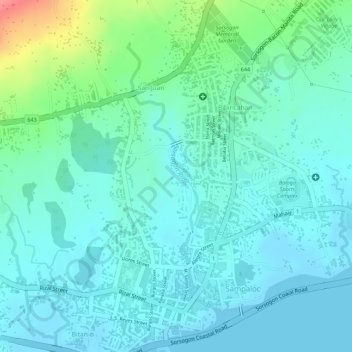
Name: Sorsogon River topographic map, elevation, terrain.
Average elevation: 19 m
Minimum elevation: 0 m
Maximum elevation: 84 m
Thank you for supporting this site ❤️
Make a donation
Make a donation
Other topographic maps
Click on a map to view its topography, its elevation and its terrain.
Pocdol Mountains
Philippines > Sorsogon > Sorsogon City
The Pocdol Mountains form part of the boundary between the provinces of Albay and Sorsogon, in Region V, on the island of Luzon, in the Philippines. The group is located south-east of Mayon Volcano, between Albay Gulf and Sorsogon Bay, at 13°3'0"N, 123°57'30"E. The mountains have a triangular footprint of…
Average elevation: 46 m
Thank you for supporting this site ❤️
Make a donation
Make a donation