
Δήμος Πολυγύρου topographic map
Interactive map
Click on the map to display elevation.
About this map
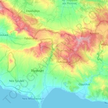
Name: Δήμος Πολυγύρου topographic map, elevation, terrain.
Average elevation: 298 m
Minimum elevation: -3 m
Maximum elevation: 1,136 m
Other topographic maps
Click on a map to view its topography, its elevation and its terrain.
Tigania Beach
Greece > Macedonia and Thrace > Chalkidiki Regional Unit > Toroni Municipal Unit
Tigania Beach, Toroni Municipal Unit, Municipality of Sithonia, Chalkidiki Regional Unit, Central Macedonia, Macedonia and Thrace, Greece
Average elevation: 11 m
Αγία Παρασκευή
Greece > Macedonia and Thrace > Chalkidiki Regional Unit > Pallini Municipal Unit
Αγία Παρασκευή, Pallini Municipal Unit, Kassandra Municipality, Chalkidiki Regional Unit, Central Macedonia, Macedonia and Thrace, 630 85, Greece
Average elevation: 165 m