
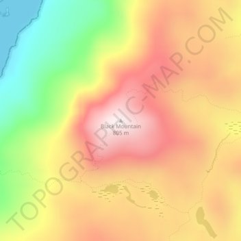
Black Mountain topographic map
Interactive map
Click on the map to display elevation.
About this map
Name: Black Mountain topographic map, elevation, terrain.
Average elevation: 487 m
Minimum elevation: 99 m
Maximum elevation: 794 m
Black Mountain is a mountain located in Washington County, New York, of which its peak is the highest point. Isolated from the rest of the Adirondack Mountains by Lake George, Black Mtn. has the seventh highest topographic prominence of all the mountains in New York. Black Mountain also has the highest elevation of any of the peaks which surround Lake George and offers unobstructed views of the lake from its summit.
Other topographic maps
Click on a map to view its topography, its elevation and its terrain.
Bald Mountain
United States > New York > Washington County
Bald Mountain, Washington County, New York, United States
Average elevation: 261 m
Village of Cambridge
United States > New York > Washington County
Village of Cambridge, Town of White Creek, Washington County, New York, United States
Average elevation: 165 m
Town of Dresden
United States > New York > Washington County
Town of Dresden, Washington County, New York, United States
Average elevation: 249 m
West Hebron
United States > New York > Washington County > West Hebron
West Hebron, Town of Hebron, Washington County, New York, 12865, United States
Average elevation: 209 m
Putnam Station
United States > New York > Washington County > Putnam Station
Putnam Station, Town of Putnam, Washington County, New York, United States
Average elevation: 83 m
West Cambridge
United States > New York > Washington County > Town of Cambridge
West Cambridge, Town of Cambridge, Washington County, New York, United States
Average elevation: 199 m
Village of Fort Edward
United States > New York > Washington County
Village of Fort Edward, Town of Fort Edward, Washington County, New York, United States
Average elevation: 52 m