
Mount Ainos topographic map
Interactive map
Click on the map to display elevation.
About this map
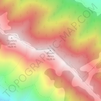
Name: Mount Ainos topographic map, elevation, terrain.
Average elevation: 1,234 m
Minimum elevation: 564 m
Maximum elevation: 1,615 m
Other topographic maps
Click on a map to view its topography, its elevation and its terrain.
Κοινότητα Ιρίων
Greece > Peloponnese, West Greece and Ionian Sea > Argos > Kantia
Κοινότητα Ιρίων, Kantia, Argos, Δήμος Ναυπλιέων, Argolis Regional Unit, Peloponnese Region, Peloponnese, West Greece and Ionian Sea, 21060, Greece
Average elevation: 68 m
Imerovigli
Greece > Peloponnese, West Greece and Ionian Sea > Othonoi Municipal Unit
Imerovigli, Othonoi Municipal Unit, Δήμος Κέρκυρας, Corfu Regional Unit, Ionian Islands Region, Peloponnese, West Greece and Ionian Sea, Greece
Average elevation: 88 m