
Thank you for supporting this site ❤️
Make a donation
Make a donation
Navenby topographic map
Click on the map to display elevation.
Thank you for supporting this site ❤️
Make a donation
Make a donation
About this map
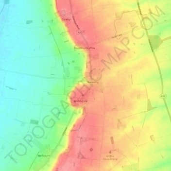
Name: Navenby topographic map, elevation, terrain.
Location: Navenby, North Kesteven, Lincolnshire, England, United Kingdom (53.08856 -0.60483 53.12177 -0.48584)
Average elevation: 47 m
Minimum elevation: 6 m
Maximum elevation: 91 m
Thank you for supporting this site ❤️
Make a donation
Make a donation
Other topographic maps
Click on a map to view its topography, its elevation and its terrain.