
Thank you for supporting this site ❤️
Make a donation
Make a donation
Stordal topographic map
Click on the map to display elevation.
Thank you for supporting this site ❤️
Make a donation
Make a donation
About this map
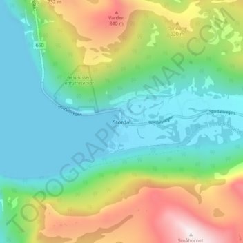
Name: Stordal topographic map, elevation, terrain.
Location: Stordal, Fjord, Møre og Romsdal, Norway (62.36265 6.96705 62.40265 7.00705)
Average elevation: 333 m
Minimum elevation: -9 m
Maximum elevation: 1,074 m
Thank you for supporting this site ❤️
Make a donation
Make a donation