
Thank you for supporting this site ❤️
Make a donation
Make a donation
Holland topographic map
Click on the map to display elevation.
Thank you for supporting this site ❤️
Make a donation
Make a donation
Holland
Holland is the highest town in Orleans County. Perhaps due to its high altitude, Holland has historically had the coolest weather and highest rate of snowfall in Orleans County.
Thank you for supporting this site ❤️
Make a donation
Make a donation
About this map
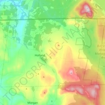
Name: Holland topographic map, elevation, terrain.
Location: Holland, Orleans County, Vermont, 05830, United States (44.93099 -72.06578 45.00837 -71.89931)
Average elevation: 471 m
Minimum elevation: 313 m
Maximum elevation: 738 m
Thank you for supporting this site ❤️
Make a donation
Make a donation
Other topographic maps
Click on a map to view its topography, its elevation and its terrain.
Thank you for supporting this site ❤️
Make a donation
Make a donation
Thank you for supporting this site ❤️
Make a donation
Make a donation