
Pratteln topographic map
Interactive map
Click on the map to display elevation.
About this map
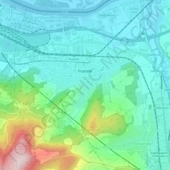
Name: Pratteln topographic map, elevation, terrain.
Location: Pratteln, Bezirk Liestal, Basel-Landschaft, 4133, Schweiz (47.49687 7.66612 47.53518 7.72063)
Average elevation: 351 m
Minimum elevation: 256 m
Maximum elevation: 666 m
Other topographic maps
Click on a map to view its topography, its elevation and its terrain.
Bubendorf
Schweiz > Basel-Landschaft > Bezirk Liestal
Bubendorf, Bezirk Liestal, Basel-Landschaft, 4416, Schweiz
Average elevation: 467 m
Frenkendorf
Schweiz > Basel-Landschaft > Bezirk Liestal
Frenkendorf, Bezirk Liestal, Basel-Landschaft, 4402, Schweiz
Average elevation: 381 m
Füllinsdorf
Schweiz > Basel-Landschaft > Bezirk Liestal
Füllinsdorf, Bezirk Liestal, Basel-Landschaft, 4414, Schweiz
Average elevation: 358 m
Ziefen
Schweiz > Basel-Landschaft > Bezirk Liestal
Ziefen, Bezirk Liestal, Basel-Landschaft, 4417, Schweiz
Average elevation: 517 m