
La Chaux-de-Fonds topographic map
Interactive map
Click on the map to display elevation.
About this map
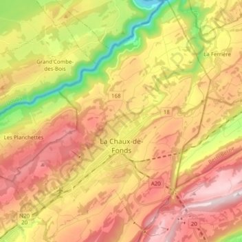
Name: La Chaux-de-Fonds topographic map, elevation, terrain.
Location: La Chaux-de-Fonds, Neuenburg, Schweiz (47.06165 6.76420 47.16559 6.88880)
Average elevation: 1,039 m
Minimum elevation: 609 m
Maximum elevation: 1,414 m
La Chaux-de-Fonds liegt auf 992 m ü. M., rund 15 km nordnordwestlich der Kantonshauptstadt Neuenburg (Luftlinie), nahe der Grenze zum französischen Franche-Comté. Die Industriestadt erstreckt sich in einem breiten Hochtal ohne oberirdisches Fliessgewässer im Neuenburger Jura, zwischen den Höhen von Mont Sagne im Südosten und Pouillerel im Nordwesten.
Other topographic maps
Click on a map to view its topography, its elevation and its terrain.
Grotte de la Cascade
Schweiz > Neuenburg > Val-de-Travers > Môtiers
Grotte de la Cascade, Grande Rue, Môtiers, Val-de-Travers, Neuenburg, 2112, Schweiz
Average elevation: 885 m