
Halifax topographic map
Click on the map to display elevation.
Halifax
Topographically, Halifax is located in the south-eastern corner of the moorland region called the South Pennines. Halifax is situated about 4 miles (6 km) from the M62 motorway, close to Bradford and Huddersfield. The A641 road links the town with Brighouse, Bradford and Huddersfield. The Hebble Brook joins the River Calder at Salterhebble.
About this map
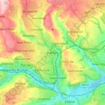
Name: Halifax topographic map, elevation, terrain.
Average elevation: 195 m
Minimum elevation: 56 m
Maximum elevation: 389 m