
Hochschober topographic map
Interactive map
Click on the map to display elevation.
About this map
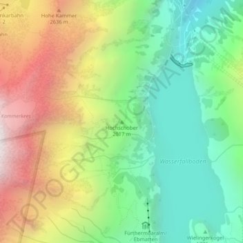
Name: Hochschober topographic map, elevation, terrain.
Average elevation: 2,085 m
Minimum elevation: 1,445 m
Maximum elevation: 3,052 m
Other topographic maps
Click on a map to view its topography, its elevation and its terrain.
Kitzsteinhorn
Österreich > Salzburg > Bezirk Zell am See > Kaprun
Kitzsteinhorn, Kaprun, Bezirk Zell am See, Salzburg, 5710, Österreich
Average elevation: 2,594 m