
Oberhueb topographic map
Interactive map
Click on the map to display elevation.
About this map
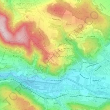
Name: Oberhueb topographic map, elevation, terrain.
Location: Oberhueb, Neftenbach, Bezirk Winterthur, Zürich, 8421, Schweiz (47.51030 8.61683 47.55030 8.65683)
Average elevation: 510 m
Minimum elevation: 373 m
Maximum elevation: 701 m
Other topographic maps
Click on a map to view its topography, its elevation and its terrain.
Tössallmend
Schweiz > Zürich > Bezirk Winterthur > Neftenbach
Tössallmend, Neftenbach, Bezirk Winterthur, Zürich, 8413, Schweiz
Average elevation: 467 m