
Le Barrage topographic map
Interactive map
Click on the map to display elevation.
About this map
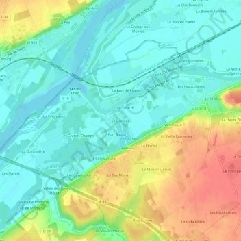
Name: Le Barrage topographic map, elevation, terrain.
Average elevation: 57 m
Minimum elevation: 35 m
Maximum elevation: 97 m
Other topographic maps
Click on a map to view its topography, its elevation and its terrain.
Les Navets
France > Centre-Val de Loire > Indre-et-Loire > Villandry
Les Navets, Villandry, Tours, Indre-et-Loire, Centre-Val de Loire, France métropolitaine, 37510, France
Average elevation: 51 m
Le Château
France > Centre-Val de Loire > Indre-et-Loire > Villandry
Le Château, Villandry, Arrondissement de Tours, Indre-et-Loire, Centre-Val de Loire, France métropolitaine, 37510, France
Average elevation: 64 m
La Motte de Gemme
France > Centre-Val de Loire > Indre-et-Loire > Villandry
La Motte de Gemme, Villandry, Arrondissement de Tours, Indre-et-Loire, Centre-Val de Loire, France métropolitaine, 37510, France
Average elevation: 61 m
Les Hucaudières
France > Centre-Val de Loire > Indre-et-Loire > Villandry
Les Hucaudières, Villandry, Arrondissement de Tours, Indre-et-Loire, Centre-Val de Loire, France métropolitaine, 37510, France
Average elevation: 60 m