
East Sussex topographic map
Interactive map
Click on the map to display elevation.
About this map
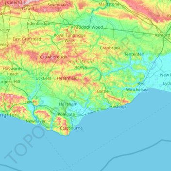
Name: East Sussex topographic map, elevation, terrain.
Location: East Sussex, Angleterre, Royaume-Uni (50.73343 -0.24508 51.14746 0.86786)
Average elevation: 44 m
Minimum elevation: -2 m
Maximum elevation: 270 m
Other topographic maps
Click on a map to view its topography, its elevation and its terrain.
Brighton
Royaume-Uni > Angleterre > East Sussex
Brighton, East Sussex, Angleterre, BN1 1HH, Royaume-Uni
Average elevation: 28 m
Lewes
Royaume-Uni > Angleterre > East Sussex
Lewes, East Sussex, Angleterre, Royaume-Uni
Average elevation: 40 m
Wych Cross
Royaume-Uni > Angleterre > East Sussex > Wealden
Wych Cross, Forest Row, Wealden, East Sussex, Angleterre, RH18 5JL, Royaume-Uni
Average elevation: 148 m