
Tiger topographic map
Interactive map
Click on the map to display elevation.
About this map
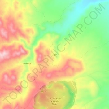
Name: Tiger topographic map, elevation, terrain.
Location: Tiger, Pinal County, Arizona, 85618, United States (32.68785 -110.70232 32.72785 -110.66232)
Average elevation: 928 m
Minimum elevation: 775 m
Maximum elevation: 1,070 m
Other topographic maps
Click on a map to view its topography, its elevation and its terrain.
Queen Valley
United States > Arizona > Pinal County
Queen Valley, Pinal County, Arizona, United States
Average elevation: 633 m
San Tan Valley
United States > Arizona > Pinal County
San Tan Valley, Pinal County, Arizona, 85243, United States
Average elevation: 463 m
Casa Grande
United States > Arizona > Pinal County
Casa Grande, Pinal County, Arizona, United States
Average elevation: 439 m