
Make a donation
Baja California Sur topographic map
Click on the map to display elevation.
Make a donation
Baja California Sur
The climate of the state is dry, with an average annual temperature of 18–22 °C and average annual rainfall of less than 200mm. The lower elevations are the driest and hottest, with summer daytime temperatures above 40 °C; wintertime temperatures may fall below freezing. The exception to desert conditions is the Los Cabos region, classified as semi-moist because of Pacific hurricane activity which affects the region. In the spring, prevailing winds are from the west and in the summer from the south and southwest. In the fall, they are from the northwest and in the winter from the north and northwest.
Make a donation
About this map
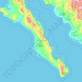
Name: Baja California Sur topographic map, elevation, terrain.
Location: Baja California Sur, Mexico (22.87163 -115.76919 28.00000 -109.41317)
Average elevation: 90 m
Minimum elevation: -5 m
Maximum elevation: 2,265 m
Make a donation
Other topographic maps
Click on a map to view its topography, its elevation and its terrain.
Paseo al Monte (Camino a la Boquilla)
Mexico > Zacatecas > Moyahua de Estrada > Moyahua de Estrada
Average elevation: 1,224 m
Texcoco de Mora
Mexico > State of Mexico > Texcoco
Tescoco lies about 25 km east of the centre of Mexico City. Major elevations in the municipality include the Tlaloc Mountain (4,500 meters) the Tetzcutzinco, Moyotepec and Tecuachacho. Most elevations are named after the major community to be found on them. There are also a number of small canyons. Part of the…
Average elevation: 2,262 m
Make a donation
Make a donation
Make a donation
Make a donation
Ciudad Victoria
Mexico > Tamaulipas > Victoria
Ciudad Victoria has a climate on the border of humid subtropical (Köppen Cfa/Cwa) and hot semi-arid (BSh). Its weather is characterised by short warm winters and long hot to sweltering summers. Temperatures rarely drop below 0 °C (32 °F) — the lowest recorded temperature was −6 °C (21.2 °F) and the…
Average elevation: 518 m
Make a donation
Hecelchakán
Mexico > Campeche > Hecelchakán
It is at an altitude of 10 m above sea level.
Average elevation: 34 m
Make a donation
Chihuahua
Mexico > Chihuahua > Municipio de Chihuahua
Chihuahua lies on the western side of the Chihuahuan Desert ecoregion and as such has a semiarid climate (Köppen climate classification BSh). However, it is not as hot as most of the lower elevated portions of the desert to the east owing to an altitude of almost 1,500 metres (4,900 feet) above sea level.
Average elevation: 1,555 m
Make a donation
Piedras Negras
Mexico > Coahuila > Municipio de Piedras Negras > Piedras Negras
Average elevation: 256 m
Make a donation