
Thank you for supporting this site ❤️
Make a donation
Make a donation
Port Wing topographic map
Click on the map to display elevation.
Thank you for supporting this site ❤️
Make a donation
Make a donation
About this map
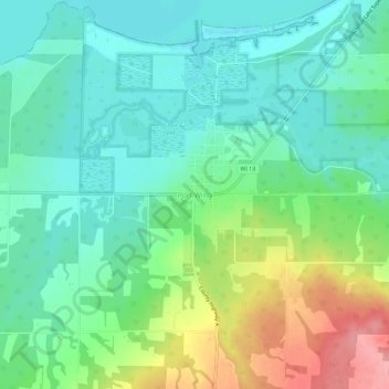
Name: Port Wing topographic map, elevation, terrain.
Average elevation: 204 m
Minimum elevation: 170 m
Maximum elevation: 282 m
Thank you for supporting this site ❤️
Make a donation
Make a donation
Other topographic maps
Click on a map to view its topography, its elevation and its terrain.
Thank you for supporting this site ❤️
Make a donation
Make a donation
Thank you for supporting this site ❤️
Make a donation
Make a donation
Bayfield
United States > Wisconsin > Bayfield County
Bayfield was named in 1856 for Henry Bayfield, a British Royal Topographic Engineer who explored the region in 1822–23. A post office has been in operation at Bayfield since 1856.
Average elevation: 245 m
Thank you for supporting this site ❤️
Make a donation
Make a donation