
Klosters-Serneus topographic map
Interactive map
Click on the map to display elevation.
About this map
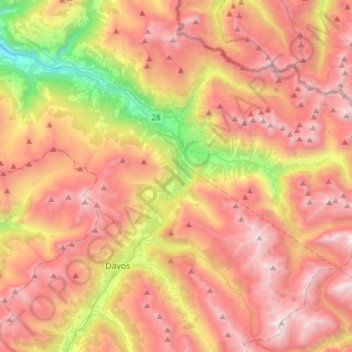
Name: Klosters-Serneus topographic map, elevation, terrain.
Location: Klosters-Serneus, Prättigau/Davos, Graubünden, Schweiz (46.76283 9.78957 46.93651 10.09692)
Average elevation: 2,217 m
Minimum elevation: 951 m
Maximum elevation: 3,394 m
Other topographic maps
Click on a map to view its topography, its elevation and its terrain.
Silvrettahorn
Schweiz > Graubünden > Klosters-Serneus
Silvrettahorn, Klosters-Serneus, Prättigau/Davos, Graubünden, Schweiz
Average elevation: 2,824 m