
Hochvernagtspitze topographic map
Interactive map
Click on the map to display elevation.
About this map
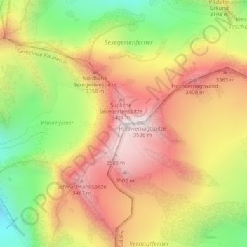
Name: Hochvernagtspitze topographic map, elevation, terrain.
Location: Hochvernagtspitze, Kaunertal, Landeck, Tirol, Oostenrijk (46.88122 10.79389 46.88132 10.79399)
Average elevation: 3,113 m
Minimum elevation: 2,652 m
Maximum elevation: 3,506 m
Other topographic maps
Click on a map to view its topography, its elevation and its terrain.
Ötztaler Alpen
Oostenrijk > Tirol > Kaunertal
Ötztaler Alpen, Kaunertal, Landeck, Tirol, Oostenrijk
Average elevation: 2,098 m