
Ochsenstock topographic map
Interactive map
Click on the map to display elevation.
About this map
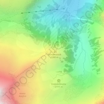
Name: Ochsenstock topographic map, elevation, terrain.
Location: Ochsenstock, Glarus Süd, Glarus, Schweiz (46.82870 8.94748 46.82880 8.94758)
Average elevation: 1,977 m
Minimum elevation: 1,297 m
Maximum elevation: 3,058 m
Other topographic maps
Click on a map to view its topography, its elevation and its terrain.
Schwändi
Schweiz > Glarus > Glarus Süd
Schwändi, Glarus Süd, Glarus, 8762, Schweiz
Average elevation: 866 m
Schwanden
Schweiz > Glarus > Glarus Süd > Schwanden
Schwanden, Glarus Süd, Glarus, 8762, Schweiz
Average elevation: 813 m