
Claremont topographic map
Interactive map
Click on the map to display elevation.
About this map
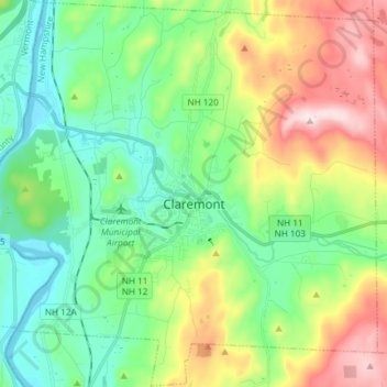
Name: Claremont topographic map, elevation, terrain.
Location: Claremont, Sullivan County, New Hampshire, United States (43.32202 -72.41617 43.42885 -72.26795)
Average elevation: 236 m
Minimum elevation: 83 m
Maximum elevation: 599 m
The city is in western Sullivan County and is bordered to the west by the Connecticut River, the boundary between New Hampshire and Vermont. According to the United States Census Bureau, the city has a total area of 44.1 square miles (114.1 km2), of which 43.2 square miles (111.8 km2) are land and 0.89 square miles (2.3 km2) are water, comprising 2.04% of the town. The Sugar River flows from east to west through the center of Claremont, descending 150 feet (46 m) in elevation through the downtown, and empties into the Connecticut. The highest point in the city is the summit of Green Mountain, at 2,018 feet (615 m) above sea level in the northeastern part of the city. Claremont lies fully within the Connecticut River watershed.
Other topographic maps
Click on a map to view its topography, its elevation and its terrain.
Washington
United States > New Hampshire > Sullivan County
Washington, Sullivan County, New Hampshire, 03280, United States
Average elevation: 466 m
East Unity
United States > New Hampshire > Sullivan County > Unity
East Unity, Unity, Sullivan County, New Hampshire, United States
Average elevation: 399 m
Sunapee
United States > New Hampshire > Sullivan County
Sunapee, Sullivan County, New Hampshire, United States
Average elevation: 363 m
Croydon
United States > New Hampshire > Sullivan County
Croydon, Sullivan County, New Hampshire, United States
Average elevation: 372 m
Newport
United States > New Hampshire > Sullivan County
Newport, Sullivan County, New Hampshire, United States
Average elevation: 339 m
Ryder Corner
United States > New Hampshire > Sullivan County > Croydon
Ryder Corner, Croydon, Sullivan County, New Hampshire, 03754, United States
Average elevation: 352 m
Grantham
United States > New Hampshire > Sullivan County
Grantham, Sullivan County, New Hampshire, 03753, United States
Average elevation: 419 m
Unity
United States > New Hampshire > Sullivan County
Unity, Sullivan County, New Hampshire, United States
Average elevation: 369 m
Green Mountain
United States > New Hampshire > Sullivan County > Claremont
Green Mountain, Claremont, Sullivan County, New Hampshire, United States
Average elevation: 446 m
Goshen
United States > New Hampshire > Sullivan County > Goshen
Goshen, Sullivan County, New Hampshire, 03752, United States
Average elevation: 419 m
Eastman
United States > New Hampshire > Sullivan County > Grantham > Eastman
Eastman, Grantham, Sullivan County, New Hampshire, 03753, United States
Average elevation: 347 m
Acworth
United States > New Hampshire > Sullivan County
Acworth, Sullivan County, New Hampshire, 03601, United States
Average elevation: 380 m
Langdon
United States > New Hampshire > Sullivan County
Langdon, Sullivan County, New Hampshire, United States
Average elevation: 239 m
Mill Hollow
United States > New Hampshire > Sullivan County > Plainfield > Mill Hollow
Mill Hollow, Plainfield, Sullivan County, New Hampshire, 03770, United States
Average elevation: 313 m
Lempster
United States > New Hampshire > Sullivan County
Lempster, Sullivan County, New Hampshire, 03605, United States
Average elevation: 425 m
North Grantham
United States > New Hampshire > Sullivan County > Grantham > North Grantham
North Grantham, Grantham, Sullivan County, New Hampshire, 03753, United States
Average elevation: 386 m
Charlestown
United States > New Hampshire > Sullivan County
Charlestown, Sullivan County, New Hampshire, 03603, United States
Average elevation: 256 m
Plainfield
United States > New Hampshire > Sullivan County > Plainfield
Plainfield, Sullivan County, New Hampshire, United States
Average elevation: 267 m
Cornish
United States > New Hampshire > Sullivan County
Cornish, Sullivan County, New Hampshire, United States
Average elevation: 272 m